Mirpur District
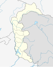
District of Azad Jammu and Kashmir, PakistanMirpur District is a district of Pakistan-administered Azad Kashmir in the disputed Kashmir region. It is one of the 10 districts of Pakistan's territory of Azad Kashmir. The Mirpur District is bounded on the north by the Kotli District, on the east by the Bhimber District, on the south by the Gujrat District of Punjab, Pakistan, on the south-west by the Jhelum District of Punjab, Pakistan, and on the west by Rawalpindi District. The district is named after its main city, Mirpur. The Mirpur District has a population of 456,200 and covers an area of 1,010 km2 (390 sq mi). The district is mainly mountainous with some plains. The Mirpur District has a humid subtropical climate which closely resembles that of the Gujrat District and the Jhelum District, the adjoining districts of Pakistan's Punjab Province.
Read article


.svg)
Top Questions
AI generatedMore questions
Nearby Places

Mirpur, Azad Kashmir
City in Azad Kashmir, Pakistan-administered Kashmir
Quaid-e-Azam Stadium
Cricket stadium in Pakistan

Mirpur University of Science & Technology
University in Mirpur, Azad Kashmir

Chitterpari
Town in Azad Kashmir, Pakistan

New Bong Escape Hydropower Project
Dam in Mangla, Azad Kashmir

Rathoa Haryam Bridge
Pakistani construction

2019 Kashmir earthquake
Earthquake in Kashmir
Siege of Mirpur
Part of the First Kashmir War in 1947